Geostationary satellite-based solar radiation analysis for meteorology & climate, renewable energy, agriculture, social science, and disaster resilience.
AMATERASS transforms geostationary meteorological satellite observations into spatially continuous solar radiation information. Developed, implemented, and long-term operated by since 2007.
Quasi-real-time solar radiation analysis started on July 7, 2007, continuing through Himawari 7, 8, and 9.
Downloads
200M+
205,031,268 AMATERASS downloads by March 2026. Over 400M total including gridded-format products.
Status
Quasi-real-time
Continuous analysis every 10 min and every 2.5 min for selected domains.
Products
Solar Flux
Global, direct & diffuse radiation at surface and TOA, with PV output estimation.
Method
Physics-based
Neural-network solver retains radiative transfer physics at speed — unlike regression or energy-flow models.
Overview
Long-term quasi-real-time Earth observation in operation.
AMATERASS is a physical analysis system for geostationary meteorological satellite observations, rather than an ordinary image-processing or empirical-model approach. Solar radiation reaches the Earth's surface through absorption by gases such as water vapor and ozone, scattering by aerosols and cloud particles, and Rayleigh scattering by molecules. AMATERASS analyzes satellite observations by accounting for these effects, including multiple reflection between the surface and atmosphere.
The system grew from radiative-transfer calculations and neural-network acceleration, then expanded into sensor calibration for stable physical use of geostationary satellite data, geolocation correction algorithms enabling latitude-longitude gridded format conversion, and applications spanning photovoltaics, solar thermal, land-surface and hydrology, agriculture and vegetation, social systems, and disaster resilience — forming a foundation for cross-disciplinary use of solar radiation data.
AMATERASS system overview and radiation product suite
Quasi-real-time processing of geostationary meteorological satellite observations into spatially continuous surface and top-of-atmosphere radiation products. Data is available approximately 10 minutes after satellite observation.
Solar radiation maps
Wide-area solar radiation products from geostationary satellite observations, updated every 10 min. These maps provide spatial context for cloud fields, terrain effects, and regional radiation variability, forming a basic input layer for renewable-energy, climate, and environmental applications.
Quasi-real-time PV applications
Solar radiation and photovoltaic power estimates at high spatial and temporal resolution, including every 2.5 min analysis.
Toward global coverage
Challenge toward multi-geostationary satellite analysis and global solar-radiation products. Extending the analysis from Himawari to multiple geostationary satellite domains supports wide-area, high-frequency monitoring across the tropics and mid-latitudes.
Physical analysis
Physical analysis of satellite observations.
AMATERASS is a physical analysis system for geostationary meteorological satellite observations, rather than an ordinary image-processing or empirical-model approach. It interprets observations through absorption, scattering, cloud effects, and surface–atmosphere radiative exchange.
The goal is to convert observed radiances into physically meaningful solar-radiation quantities—such as global, direct, and diffuse components—by combining radiative-transfer knowledge, in-situ observations, site-scale validation, and high-frequency satellite data.
From satellite radiances to physically meaningful solar-radiation quantities
Radiative-transfer knowledge, in-situ observations, site-scale validation, and high-frequency satellite data are combined to estimate global, direct, and diffuse solar-radiation components.
Radiative transfer and spectral interpretation
Satellite radiances are interpreted through atmospheric absorption and scattering by gases, aerosols, clouds, and molecules.
In-situ observation heritage
The research was built step by step from ground radiation measurements and site-scale estimation above observation points toward wide-area satellite analysis.
Validation of surface solar radiation
Satellite-based surface solar radiation estimates are evaluated against ground observations across multiple sites to verify quantitative reliability.
Physical processesThe analysis targets radiation physics rather than visual texture or object recognition in the image.
Quantitative productsThe outputs are physically interpretable radiation quantities, not merely processed satellite pictures.
Observation chainSatellite data, atmospheric theory, and ground measurements are connected in a single operational framework.
Learning algorithm
Development of the learning algorithm for radiative-transfer analysis.
AMATERASS originates from the idea of learning radiative-transfer calculations with neural networks, rather than relying only on large lookup tables. The learning algorithm was developed to estimate solar radiation from radiative parameters while retaining a physics-based interpretation.
This foundation connects radiation physics, neural-network acceleration, and quasi-real-time satellite analysis.
Development of the learning algorithm for radiative-transfer analysis
Neural networks were developed to learn radiative-transfer calculations from radiative parameters and accelerate physically grounded solar-radiation estimation. This learning approach became the computational bridge between detailed atmospheric radiation physics and operational processing of high-frequency satellite observations.
Development of the learning algorithm
The Distortion-BP method was developed to learn radiative-transfer calculations and estimate solar radiation from radiative parameters. This algorithmic foundation reduced dependence on large lookup tables and connected physical radiation theory to fast quasi-real-time satellite analysis.
Radiation-budget foundation
A neural-network solver trained on radiative-transfer calculations accelerated physically based radiation estimation by about a factor of 1,000. This speed-up made it practical to analyze wide-area, high-temporal-resolution geostationary satellite observations and produce operational atmospheric radiation-budget products.
Development history
How AMATERASS Evolved.
The AMATERASS story is not a single dataset story. Starting from atmospheric physics research aimed at understanding the radiation budget, it progressed through fast radiation calculation, satellite sensor calibration, quasi-real-time operation, and geolocation correction for high-accuracy gridded satellite products. The 2011 Great East Japan Earthquake triggered a decisive turn toward photovoltaic applications and cross-disciplinary collaboration — and the story continues with international research with NASA.
01
Learning radiative-transfer calculation
Neural-network acceleration of radiative-transfer calculations enabled fast, physically grounded solar radiation estimation.
02
Vicarious calibration for geostationary satellite observations
Calibration research with the Japan Meteorological Agency contributed to stable physical use of geostationary satellite data and WMO/GSICS-related activities (JMA/MSC calibration guide).
03
AMATERASS begins in 2007
Quasi-real-time solar radiation analysis using Himawari observations started on July 7, 2007, and continued through successive satellite generations.
04
High-accuracy gridded satellite products enabled by the Geo-information Correction method
The Geo-information Correction method enabled high-accuracy gridded geostationary satellite products for quantitative analysis.
05
Response to energy and power-system needs
After the 2011 Great East Japan Earthquake, AMATERASS expanded toward satellite-based photovoltaic estimation, actively sharing data across disciplinary boundaries with energy, power-system, climate, and social-system researchers.
06
Applications and collaborations
The system supports research and applications across meteorology & climate, renewable energy, agriculture, social science, and disaster resilience.
Geo-information Correction method / Satellite gridded format
From corrected geolocation to latitude–longitude gridded satellite products.
Geostationary satellites appear nearly stationary from Earth, enabling high-frequency observation of the same region — a major advantage for analyzing rapidly evolving atmospheric phenomena such as clouds. However, scanning mirror motion, satellite attitude variations, and navigation errors cause frame-by-frame positional shifts. Geo-information Correction method addresses this problem by correcting geolocation and enabling gridded-format data suitable for downstream analysis.
The geolocation-correction and disk-to-grid conversion capabilities developed through AMATERASS-related work formed part of the technical lineage leading to subsequent gridded geostationary satellite products, including the NASA GeoNEX L1G product workflow. The requirement for physically comparable, stable satellite data that drove AMATERASS development connects directly to the broader need for wide-area gridded products.
From geostationary disk observations to latitude–longitude gridded data
Geostationary satellites observe the Earth as disk-shaped data in satellite projection. AMATERASS-related programs convert these observations into latitude–longitude gridded data, conceptually transforming Level-1A-equivalent disk data into Level-1B-equivalent gridded products.
Geo-information correction method
Phase-only correlation and gridded-format processing correct positional shifts in Himawari and GOES-class geostationary observations. The correction stabilizes the satellite image sequence and supports quantitative mapping, compositing, and time-series analysis on latitude–longitude grids.
AMATERASS-origin algorithms in NASA GeoNEX L1G products
AMATERASS-origin geolocation correction and gridded satellite product generation programs provided to NASA NEX were used in the NASA GeoNEX L1G product workflow, together with further development, integration, and execution by the GeoNEX team.
Applications
Solar radiation information for science, energy, society, and resilience.
Meteorology & Climate
Radiation budget, clouds, aerosols, satellite calibration, and climate-model evaluation.
Renewable Energy
Photovoltaic output estimation, solar resource assessment, and distributed power systems.
Agriculture & Vegetation
Crop and fruit environments, radiation-driven productivity, and climate impact analysis.
Social Science
Regional energy planning, demand-side analysis, urban systems, and data-driven decision support.
Disaster Resilience
Distributed generation, blackout resilience, water resources, and emergency energy planning.
Selected studies
Selected studies using AMATERASS, gridded geostationary satellite data, and related algorithms.
These examples are arranged broadly in chronological order.
2013Renewable energy / Microgrids
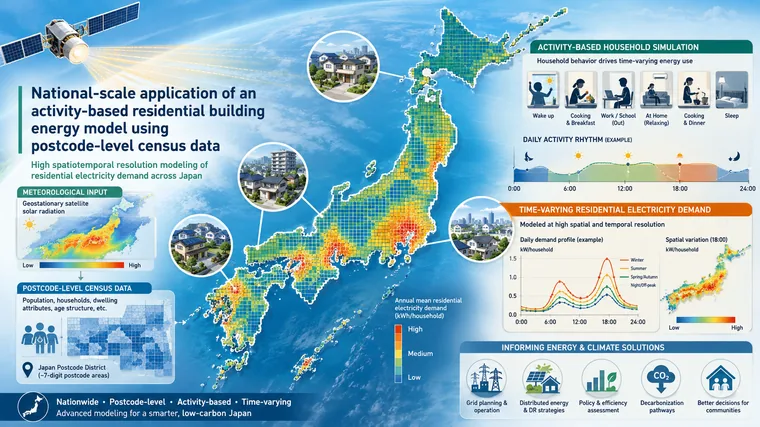
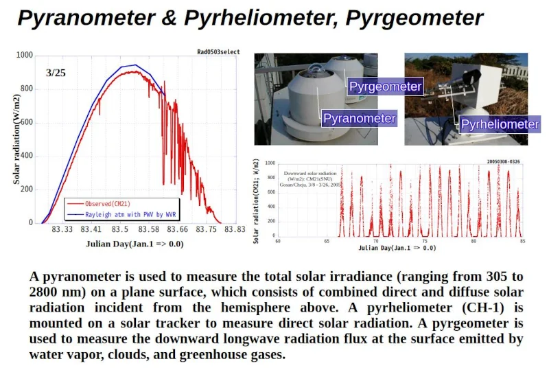
Game Theoretic Receding Horizon Cooperative Network Formation for Distributed Microgrids: Variability Reduction of Photovoltaics
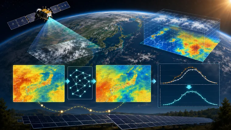
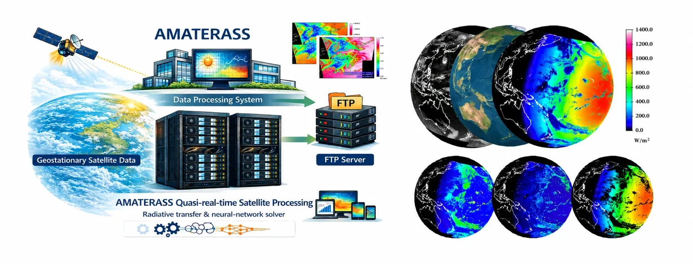
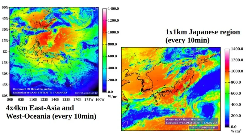
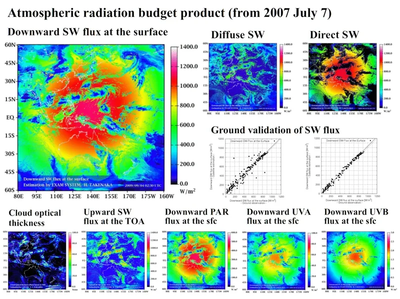
Distributed microgrids and photovoltaic variability reduction supported by AMATERASS/EXAM-related solar-radiation information.
National-scale application of an activity-based residential building energy model using postcode-level census data
An activity-based residential energy model is applied nationally across Japan at postcode-district scale, using AMATERASS-derived meteorological input.
Post-processing correction method for surface solar irradiance forecast data from the numerical weather model using geostationary satellite observation data
Geostationary satellite observations are fused with numerical weather prediction output to improve surface solar irradiance forecast skill.
AMATERASS analysis products have been widely used as fundamental solar-radiation and renewable-energy datasets across multiple research fields and projects.
MEXT Special Expense ProjectVirtual Laboratory for Diagnosis of the Earth Climate System地球気候系の診断に関わるバーチャルラボラトリーの形成/気候診断VLプロジェクト
METI / Agency for Natural Resources and EnergyDemonstration Project for the Development of Photovoltaic Power Output Forecasting Technology太陽光発電出力予測技術開発実証事業
JST CRESTCreation and Integration of Theory and Fundamental Technologies for Distributed Cooperative Energy Management Systems分散協調型エネルギー管理システム構築のための理論および基盤技術の創出と融合展開
METI / New Energy TechnologiesSurvey of Medium- and High-Temperature Solar Thermal Utilization and Development of Evaluation Methods for Various Systems新エネルギー等共通基盤整備促進事業/中高温太陽熱利用調査及び各種システム評価法開発
MEXT Space Science and Technology PromotionWide-Area Crop Yield Estimation and Short-Term Prediction over the Pacific Rim Using Satellite Inputs for Food Security食糧安全保障に向けた衛星入力を活用した環太平洋域での広域収量推定および短期予測の試み
MEXT / DIAS Earth Environmental Information PlatformFeasibility Study on Global Deployment of Solar Radiation and Photovoltaic Power Output Products Derived from Geostationary Meteorological Satellites地球環境情報プラットホーム構築推進プログラム基幹アプリケーションFS
JST SATREPSDevelopment of Innovative Climate-Resilient Technologies for Improving Water-Use Efficiency and Controlling Salinity in the Aral Sea Regionアラル海地域における水利用効率と塩害の制御に向けた気候にレジリエントな革新的技術開発
Media coverage
Media Coverage and Public Visibility.
AMATERASS and related satellite-based solar-radiation research have been introduced through newspapers, institutional news, and public outreach articles.
Hideaki Takenaka specializes in satellite remote sensing, atmospheric radiation, and solar-radiation energy applications. He studied atmospheric radiation at the Center for Environmental Remote Sensing (CEReS), Chiba University, and received his Ph.D. in Science in 2009.
He developed AMATERASS, a quasi-real-time solar radiation analysis system using geostationary satellite data. Since July 7, 2007, he has continuously operated quasi-real-time solar radiation analysis based on Himawari geostationary meteorological satellite observations.
He has also contributed to the physical reliability of geostationary satellite analysis through joint research with JMA/MSC, where the developed vicarious calibration method was proposed to WMO/GSICS by JMA as Japan's calibration technique. After the 2011 earthquake, he expanded into renewable-energy and power-system studies. He also developed a phase-only-correlation-based geolocation correction method, later connected to collaboration with NASA Ames and the NASA GeoNEX L1G product workflow. The analysis results of AMATERASS have been widely utilized as fundamental data across various research fields.